|
|
#非洲
联合国通过了一项无约束力的决议,正式认可“Equal Earth”投影地图。该地图能够更公平地展现地球陆地的真实大小。目前普遍使用的“Mercator”投影地图极大地夸大了南北两极附近的陆地面积,导致非洲看起来小得多。在Mercator投影中,靠近南北两极的国家比其实际大小大2到14倍不等。而在Equal Earth投影中,这些变形被……\n\n我们邀请了研究地图社会与传播力量的制图师兼地理学家Jack Swab和Derek Alderman来对此进行解释。\n\n通过WhatsApp或LinkedIn了解最新头条新闻\n\n地图投影是制图师用来将圆形的、三维的地球转换为我们在墙上或电脑屏幕上看到的平面的、二维地图的一种技术。当制图师将地球压平时,地图就会发生变形,从而改变形状和面积。没有任何一种地图投影不会使地球变形,但某些投影比其他投影更适合特定的用途。\n\n制图师的工作是从数百种不同的地图投影中进行选择,并考虑地图的焦点以及它的用途。没有任何一种单独的投影适用于所有用途。这种新的Equal Earth投影比Mercator投影更适合用于制作全球尺度的世界地图,以满足教育、公众沟通和政策制定的需求。\n\nEqual Earth有助于人们更准确地理解国家和大陆的相对大小,为公众在人口、环境、发展、政治及其他全球模式方面比较不同地区提供了更公平的视角。\n\n虽然Mercator投影不适合展示地球陆地的面积,但我们也不会看到它彻底消失。例如,它对于导航非常有用,因为它能保持两点之间罗盘方位角的准确性,而无需重新计算。\n\n这就是为什么大多数在线地图平台(如Google Maps或Apple Maps)都依赖Mercator投影的变体来提供路线指引的原因。将Equal Earth投影用于导航,其效果不如Mercator投影。
中文导读
跟上WhatsApp上的最新头条| LinkedIn
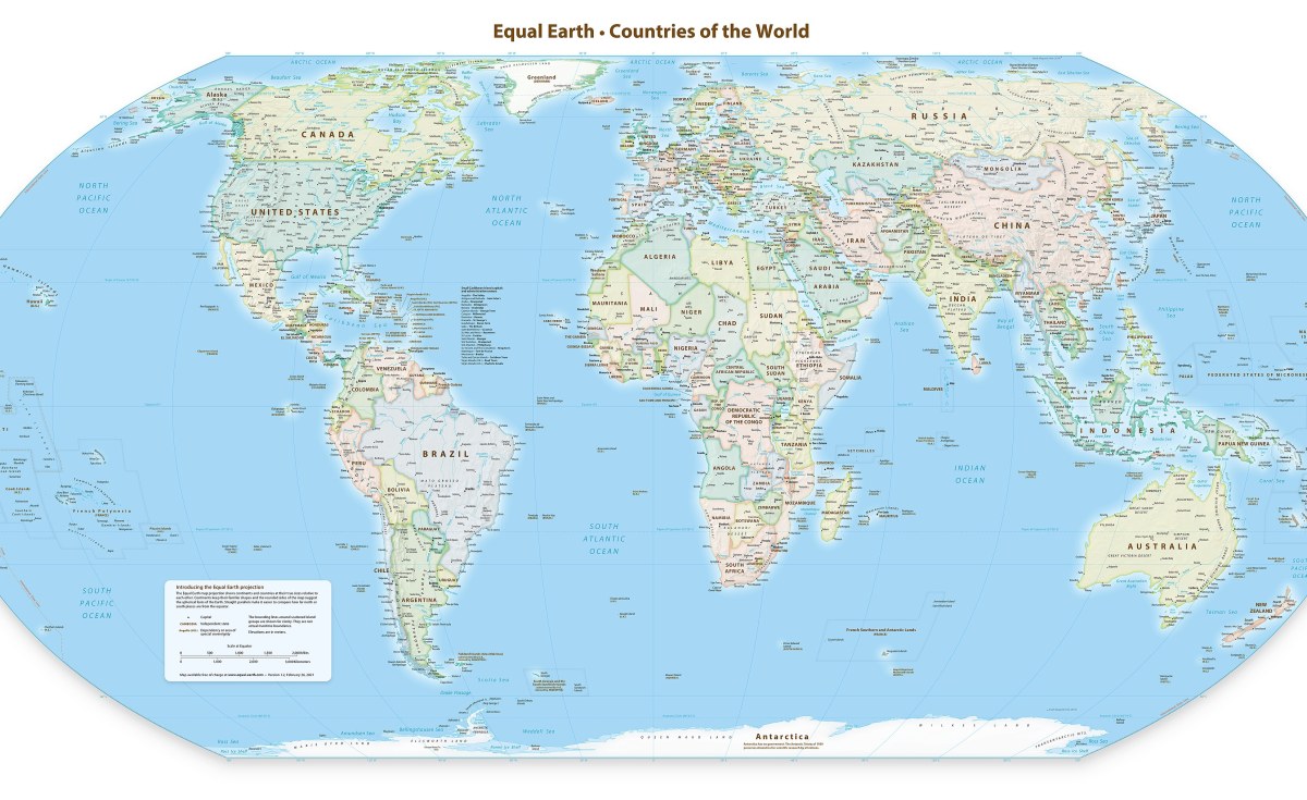
原文原文 / Original TextThe UN has passed a non-binding resolution to endorse the Equal Earth Projection, a map which more fairly represents the true size of the Earth's landmasses. The current commonly used projection, called the Mercator Projection, greatly exaggerates land towards the north and south poles, which makes Africa look much smaller. In the Mercator projection, countries near the north and south pole can be anywhere from two to 14 times their true size. In the Equal Earth projection these distortions are
We asked Jack Swab and Derek Alderman, cartographers and geographers who study the social and communicative power of maps, to explain what's going on.
Keep up with the latest headlines on WhatsApp | LinkedIn
A map projection is a technique that cartographers (map-makers) use to transform the round, three-dimensional Earth into a flat, two-dimensional map that we see on the wall or on our computer screen. As cartographers flatten the globe, the map becomes distorted, changing shapes and areas. There is no map projection that does not distort the Earth, but some projections are better suited for some uses than others.
A cartographer's job is to choose from the hundreds of different map projections, and consider where the map is focused and how it is going to be used. No single projection is best for every use. This new Equal Earth projection is better suited than Mercator for producing global scale world maps for educational, public communication and policy purposes.
The Equal Earth supports a more accurate geographic understanding of the relative sizes of countries and continents. It provides a fairer perspective for the public to compare regions in terms of population, environment, development, politics and other global patterns.
While the Mercator projection isn't good for showing the size of the Earth's landmasses, we won't see it totally disappear. For example, it's very useful for navigational purposes as it maintains the accuracy of a compass bearing between two points without having to recalculate it.
This is why most online mapping platforms like Google Maps or Apple Maps rely on a variation of the Mercator projection to provide directions. Using the Equal Earth projection for navigation would not be as effective as the Mercator projection.
本文为英文资讯,中文内容由机器翻译生成,仅供参考。详情请阅读文末原文。
—— 资讯转载说明 ——
本文由非洲论坛根据公开信息整理,供中国读者查阅,不代表本站立场。
来源:AllAfrica (https://allafrica.com/)
原文链接:https://allafrica.com/stories/202609130140.html
转载请遵守原发布方版权与引用规定。 |
|


 发表于 2026-9-2 22:49:59